Gander International Airport (YQX) → Musgrave Harbour
Gander Airport (YQX) to Musgrave Harbour and the Straight Shore
- Drive time
- 1h 25m
- Distance
- 90.8 km
- Routes
- 330
Conservative model estimate, Gander International Airport (YQX) to Musgrave Harbour — no stops, dry roads. Many of Newfoundland's provincial routes carry no speed limit in the open map data, so the router assumes a slow default: a driver who knows the road will beat this. Source: OSRM driving profile, terminal door to town centre, checked 2026-09-02.
Drive it with your own nav:Organic Maps →OsmAnd →Apple →Google →Waze →The first two run on OpenStreetMap and don't track you — the same map this site is built from.
Or take the whole route with you: Download the GPX → — the measured drive plus every stop as a waypoint, for Organic Maps, OsmAnd or any Garmin, no account and no signal needed once it's on the device.
No one has sent a recording of this drive yet.Be the first — send the track →
The terminal side — parking, arrivals, ground transport — is the airport's own information: Gander International Airport →
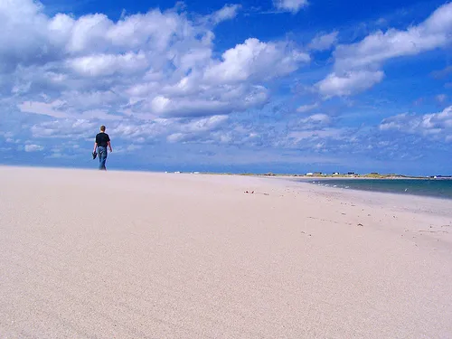

This is the shortest new coast Gander offers: one highway number the whole way. Route 330 leaves the airport’s front door, crosses the Gander River country, rounds Hamilton Sound through Carmanville, and puts you on the Straight Shore before the coffee from the terminal is finished.
What is there is the shore itself. OpenStreetMap maps the beach as continuous, kilometre-scale sand on both sides of the town — rare on a coastline that mostly meets the sea as rock. The town’s own landmarks are thinner on the map than they are on the ground: Banting’s memorial park, which the community keeps, is not yet mapped at all — if you can fix that, the contributor page says how, and this page gets better the day you do.
And the road does not end here either: Route 330 carries on down the shore to Lumsden (OpenStreetMap node/107364008), which the map rings with beach on every seaward side — eleven mapped stretches of sand around one hamlet. Adding it to this drive costs 68.3 km and about 69 minutes out and back, by the same measure as everything else here.
Faded on the map: the other measured drives from Gander International into this same region, each its own page — Farewell ferry terminal (1h 21m), Farewell ferry terminal (1h 21m), New-Wes-Valley (1h 56m). Where a faded line leaves the solid one is where that drive forks from this one.
Worth stopping for
Gander Old Town SiteDetour
The mapped historic ruins of the original Gander townsite, minutes from the terminal — the town that existed before the airport moved everyone.
Stopping here adds about 6 min and 2.8 km to the drive.
navigate: Organic · OsmAnd · Apple · Google · WazeJonathan's Pond Provincial Park ReserveDetour
A Provincial Park Reserve on Route 330 — ParksNL's category for a former camping park whose campground was privatised, kept for its natural features and run without visitor services.
Stopping here adds about 5 min and 1.3 km to the drive.
navigate: Organic · OsmAnd · Apple · Google · WazeCarmanville Wetlands Interpretation Center
Carmanville's mapped wetlands interpretation site, beside the driven line as Route 330 rounds Hamilton Sound — the mapped wetlands boardwalk is this shore's birdwatching stop, and the mapped 'Birdingwatching Trail' in its network says so in OSM's own spelling.
Stopping here adds about 0 min and 0 km to the drive.
navigate: Organic · OsmAnd · Apple · Google · Waze
What has been recorded near here
Species reported within 50 km of Musgrave Harbour and shared to GBIF, the international record of species occurrences. The useful column is when — the months the reports cluster in.
- Northern gannetseabirdMorus bassanusReports cluster in August, July, June910 reports on record
- Atlantic puffinseabirdFratercula arcticaReports cluster in July, August, June245 reports on record
- Humpback whalewhaleMegaptera novaeangliaeReports cluster in August, July46 reports on record
- Fin whalewhaleBalaenoptera physalusReports cluster in October, August, September35 reports on record
- Minke whalewhaleBalaenoptera acutorostrataReports cluster in July, August3 reports on record
What this is not
- Not how many there are. A report means somebody looked, saw and wrote it down. A busy harbour with tour boats reports more than an empty coast with the same animals in it.
- Not a sighting you are promised. Nothing here says you will see one.
- Not complete. Only species we ask GBIF about appear, and only where somebody reported them.
From GBIF, queried 2026-09-14 — their record, not a copy of it.
When you get to Musgrave Harbour
- Where to eat in Musgrave Harbour → — 3 places the open map records, alphabetically, with addresses and phone numbers.
Doing it electric
- Fast chargers on this drive
- Gander km 2
- Longest stretch without one
- 89 km
- Gander → Musgrave Harbour, of 91 km driven
- Nearest fast charger to Musgrave Harbour
- 90.9 km
- 1h 24m by road, at Gander
NL Hydro lists an ultra-fast site coming in 2026 at Gander (km 2) — not counted above until it opens.
Source: NL Hydro's published fast-charging network map, exported 2026-09-13 — sites within 3 km of this route's measured line, the km read along it, the drive to the nearest site priced by OSRM. NL Hydro lists these as 62.5 kW DC with CCS and CHAdeMO plugs on a ChargePoint account; whether one is free or working right now is the app's to say. Level 2 chargers in towns are not counted.
Paved or not, per the map
- Mapped as unpaved
- none
- Mapped as paved
- 41%
- 33.9 km of 90.8 km driven
- No surface tag on the map
- 59%
- 48.6 km the map does not describe either way
Why it matters: Hertz Canada’s published rental terms — the one set of Canadian rental terms we could read in full, quoted not recommended — list “use off paved roads or on roads which are not regularly maintained” as misconduct that voids the damage waiver. Read the agreement you sign before leaving the lot. The terms themselves. Source for these figures: OSRM driving profile, stored route query, with node annotations; OpenStreetMap surface tags via Overpass, checked 2026-09-06. A road with no tag is unknown, not paved; what any road is like today is on 511.
Eating on the way — measured, not recommended
28 places to eat that the open map data records within 2 km of this drive, in the order you would pass them. No stars, no prices, no opinions, and no opening hours — distance along the road is the one thing measured here that a directory cannot give you.
The longest stretch with nothing mapped on it is 87.6 km — after Little Caesars, to Musgrave Harbour. That is the figure worth planning around.
- Tim Hortonscafékm 2 · 1310 m off the road
- Pizza Delightrestaurantkm 2 · 314 m off the road
- Subwayfast foodkm 2
- McDonald'sfast foodkm 2
- A&Wfast foodkm 2 · 1553 m off the road
- Mary Brown'sfast foodkm 2 · 1394 m off the road
- Subwayfast foodkm 2 · 1527 m off the road
- Mystic Roomrestaurantkm 2 · 423 m off the road
- DQ Grill & Chillfast foodkm 2 · 1164 m off the road
- Swiss Chaletrestaurantkm 2 · 235 m off the road
- Robin's Donutsfast foodkm 2 · 264 m off the road
- KFCfast foodkm 2.2 · 204 m off the road
- Ches's Fish & Chipsrestaurantkm 2.2 · 483 m off the road
- The Shawarma Stationrestaurantkm 2.2 · 250 m off the road
- Louis Geesfast foodkm 2.2 · 712 m off the road
- Jade Garden Restaurantrestaurantkm 2.2 · 640 m off the road
- New Highlight Restaurantrestaurantkm 2.2 · 620 m off the road
- Grecofast foodkm 2.2 · 632 m off the road
- Tim Hortonscafékm 2.2 · 227 m off the road
- Jumping Bean Coffee Companycafékm 2.3 · 583 m off the road
- Lilly's Landing Family Restaurantrestaurantkm 2.3 · 547 m off the road
- Pizza Housefast foodkm 2.3 · 595 m off the road
- East Ocean Restaurantfast foodkm 2.3 · 598 m off the road
- Tim Hortonscafékm 2.4
- The Newfoundland Tea Co. Restaurant & Shoprestaurantkm 2.6 · 627 m off the road
- Wing 'n Itrestaurantkm 2.7 · 312 m off the road
- Rosie's Restaurant & Bakeryrestaurantkm 2.7 · 779 m off the road
- Little Caesarsfast foodkm 2.8
What this list is not
- Not a recommendation. Nothing here is endorsed, reviewed or rated. It is in the order you drive past it.
- Not complete. Somewhere unmapped does not appear. This is never "all of them".
- Not open hours. We publish none, because the open data holds none. Never assume a kitchen is serving.
- Not necessarily still trading. A place that closed stays in the data until somebody removes it.
- Not for sale. No one can pay to appear here, to rank higher, or to have a rival removed.
Open map data is incomplete — somewhere unmapped does not appear here, and this is never "all of them" or "the good ones". A place that closed is also still on the map until somebody removes it, which is why no hours are shown and nothing here says a kitchen is open. From OpenStreetMap and Overture Maps (which includes data from Meta, Foursquare and AllThePlaces); swept 2026-09-12. Map the one that is missing → and every site built on the open map gains it, this one included.
Before you go
These change. We link the people who keep them current rather than copying numbers that go stale here.
MooseYear round, worst between dusk and dawn
The province states that the likelihood of injury in a moose collision is twice as high between dusk and dawn as in daytime. Route 330 runs long wooded stretches between its communities.
Check it now →Road conditionsYear round, matters most November–April
One road in, one road out — check it before you commit to the shore.
Check it now →
Arriving without a car
Every distance and time on this page is a drive. If you are not renting, here is what Gander International Airport Authority lists at this door — operators and numbers, not fares: a tariff is theirs to change, so it is linked and not copied.
No rideshare here.
No rideshare service is named anywhere on the Airport Authority's transport page. That is an absence read off the page on 2026-09-15, not an assumption — but it is the Authority's page, not a licensing register, so it says what the airport lists rather than what is legal.
Taxi
Busy Bee Cabs, which the Airport Authority says runs a 24-hour service available curbside in the Domestic Arrivals area.
Coach
DRL Coachlines runs a scheduled coach service across Newfoundland. The Airport Authority says a wheelchair-accessible bus needs 48 hours' notice.
Limousine
Nobel Limousines, listed by the Airport Authority.
Avis, Budget, National and Enterprise are listed at the airport. The Authority says accessible vehicles with wheelchair accommodation or hand controls are limited and need 48 hours' notice.
Gander International Airport Authority, read 2026-09-15 — the authority on what operates at this kerb, and the only place a current fare or timetable should come from.
Questions people actually ask
Should I fly into Gander or Deer Lake for the Straight Shore?+
Gander, overwhelmingly: 1h25 against roughly 5h16 from Deer Lake. This coast is about as far from the western door as the road network allows — it is the clearest Gander-wins answer on the site.
What is the Straight Shore?+
The low, sandy stretch of coast the road meets at Musgrave Harbour — straight by Newfoundland standards, which is the point of the name. OpenStreetMap records the shore here as continuous beach for kilometres on either side of the town, which is not how most of this island's coastline looks.
Is the beach swimmable?+
That is a question about the North Atlantic more than about the beach, and about the day more than the map. What we can say from the map is that the sand is real and long; what the water is doing is yours to judge from the shore. Bring layers either way — our gear guide says why.
Is this an iceberg drive?+
Sometimes — this coast faces the Alley — but Musgrave Harbour is not one of the viewing spots the province names, so this site won't rate it. The named spots, measured, are in the iceberg guide; the live picture is Iceberg Finder's job.
Put this map on your site
If you run a place to stay, a tour, or a town page along this drive, this map answers the question your guests already email you: how far are you from the airport? Free, no account, and the measured figures stay current because they are ours to maintain.
<iframe src="https://fromtheairport.xyz/embed/yqx-musgrave-harbour"
  width="100%" height="420" style="border:0" loading="lazy"
title="Driving route: Gander International Airport (YQX) to Musgrave Harbour"></iframe>?lat=&lon=&label= to the URL to pin your own property on the map.Every distance, drive time and coordinate on this page was checked against its source on September 2, 2026. Origin: OpenStreetMap way/154350645 — passenger terminal. Destination: OpenStreetMap node/1462653227 — Musgrave Harbour place node.